I'm a Lecturer (Assistant Professor) in Spatio-temporal Big Data Analytics, Urban Mobility and Crime Science.
Journal Articles
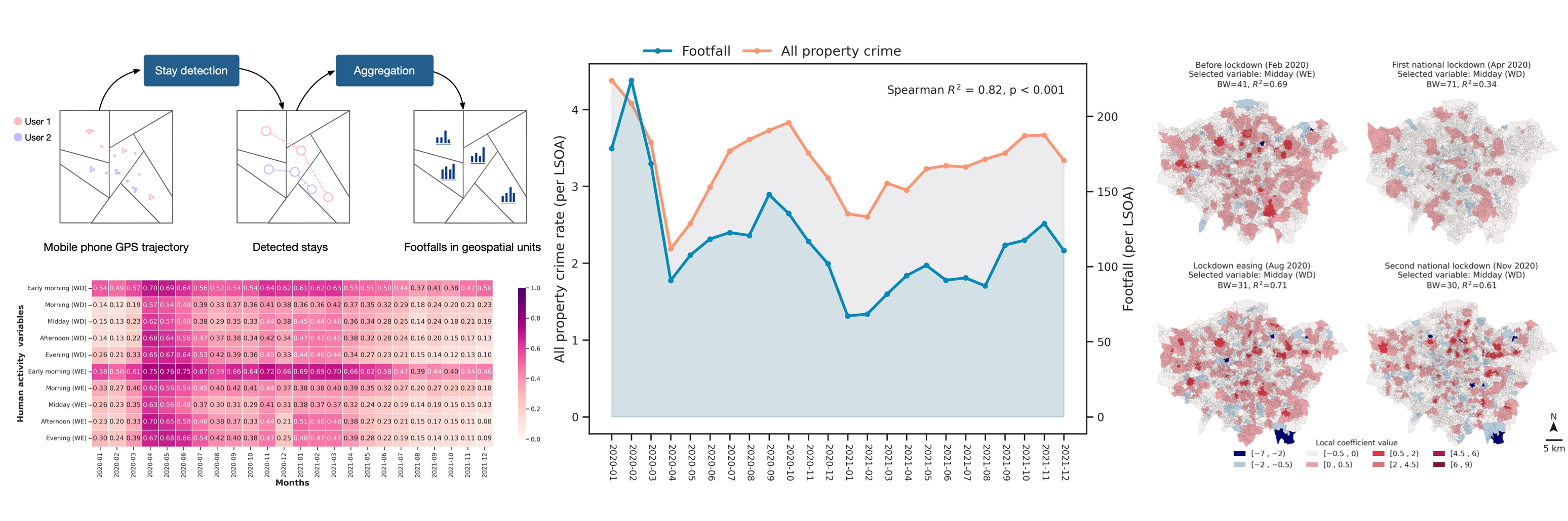
Applying dynamic human activity to disentangle property crime patterns in London during the pandemic: An empirical analysis using geo-tagged big data
Abstract: This study aimed to evaluate the relationships between different groups of explanatory variables (i.e., dynamic human activity variables, static variables of social disorganisation and crime generators, and combinations of both sets of variables) and property crime patterns across neighbourhood areas of London during the pandemic (from 2020 to 2021). Using the dynamic human activity variables sensed from mobile phone GPS big data sets, three types of ‘Least Absolute Shrinkage and Selection Operator’ (LASSO) regression models (i.e., static, dynamic, and static and dynamic) differentiated into explanatory variable groups were developed for seven types of property crime. Then, the geographically weighted regression (GWR) model was used to reveal the spatial associations between distinct explanatory variables and the specific type of crime. The findings demonstrated that human activity dynamics impose a substantially stronger influence on specific types of property crimes than other static variables. In terms of crime type, theft obtained particularly high relationships with dynamic human activity compared to other property crimes. Further analysis revealed important nuances in the spatial associations between property crimes and human activity across different contexts during the pandemic. The result provides support for crime risk prediction that considers the impact of dynamic human activity variables and their varying influences in distinct situations.
Citation: Chen, Tongxin*, Kate Bowers, and Tao Cheng. 2023. "Applying Dynamic Human Activity to Disentangle Property Crime Patterns in London during the Pandemic: An Empirical Analysis Using Geo-Tagged Big Data" ISPRS International Journal of Geo-Information 12, no.12: 488. https://doi.org/10.3390/ijgi12120488
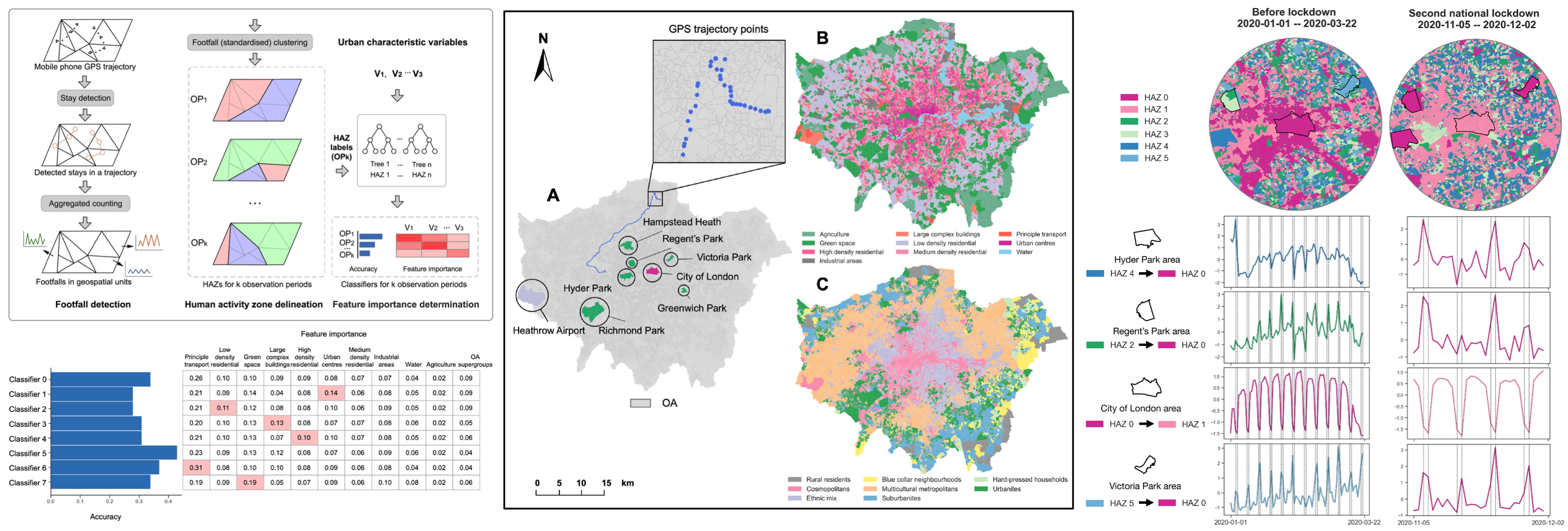
Sensing dynamic human activity zones using geo-tagged big data in Greater London, UK during the COVID-19 pandemic
Abstract: Exploration of dynamic human activity gives significant insights into understanding the urban environment and can help to reinforce scientific urban management strategies. Lots of studies are arising regarding the significant human activity changes in global metropolises and regions affected by COVID-19 containment policies. However, the variations of human activity dynamics amid different phases divided by the non-pharmaceutical intervention policies (e.g., stay-at-home, lockdown) have not been investigated across urban areas in space and time and discussed with the urban characteristic determinants. In this study, we aim to explore the influence of different restriction phases on dynamic human activity through sensing human activity zones (HAZs) and their dominated urban characteristics. Herein, we proposed an explainable analysis framework to explore the HAZ variations consisting of three parts, i.e., footfall detection, HAZs delineation and the identification of relationships between urban characteristics and HAZs. In our study area of Greater London, United Kingdom, we first utilised the footfall detection method to extract human activity metrics (footfalls) counted by visits/stays at space and time from the anonymous mobile phone GPS trajectories. Then, we characterised HAZs based on the homogeneity of daily human footfalls at census output areas (OAs) during the predefined restriction phases in the UK. Lastly, we examined the feature importance of explanatory variables as the metric of the relationship between human activity and urban characteristics using machine learning classifiers. The results show that dynamic human activity exhibits statistically significant differences in terms of the HAZ distributions across restriction phases and is strongly associated with urban characteristics (e.g., specific land use types) during the COVID-19 pandemic. These findings can improve the understanding of the variation of human activity patterns during the pandemic and offer insights into city management resource allocation in urban areas concerning dynamic human activity.
Citation: Chen, Tongxin*, Di Zhu, Tao Cheng*, Xiaowei Gao, and Huanfa Chen. "Sensing dynamic human activity zones using geo-tagged big data in Greater London, UK during the COVID-19 pandemic." Plos one 18, no. 1 (2023): e0277913.
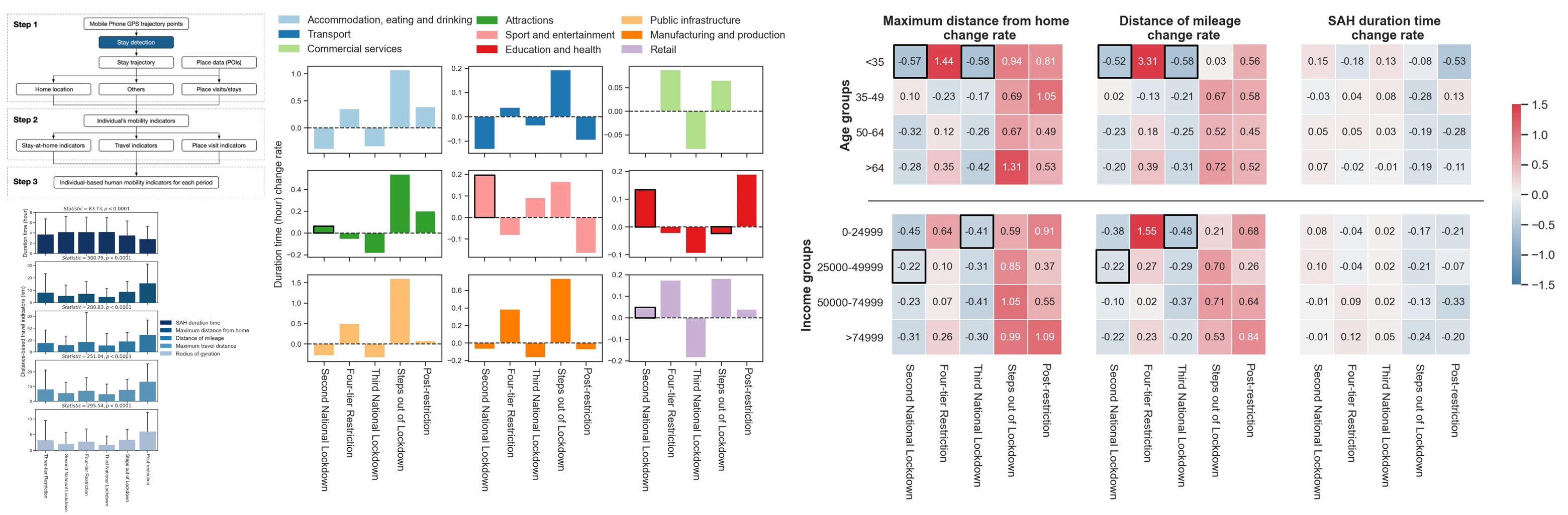
Human mobility variations in response to restriction policies during the COVID-19 pandemic: An analysis from the Virus Watch community cohort in England, UK
Abstract: Objective: Since the outbreak of COVID-19, public health and social measures to contain its transmission (e.g., social distancing and lockdowns) have dramatically changed people's lives in rural and urban areas globally. To facilitate future management of the pandemic, it is important to understand how different demographic groups adhere to such demands. This study aims to evaluate the influences of restriction policies on human mobility variations associated with socio-demographic groups in England, UK. Methods: Using mobile phone global positioning system (GPS) trajectory data, we measured variations in human mobility across socio-demographic groups during different restriction periods from Oct 14, 2020 to Sep 15, 2021. The six restriction periods which varied in degree of mobility restriction policies, denoted as “Three-tier Restriction,” “Second National Lockdown,” “Four-tier Restriction,” “Third National Lockdown,” “Steps out of Lockdown,” and “Post-restriction,” respectively. Individual human mobility was measured with respect to the time period people stayed at home, visited places outside the home, and traveled long distances. We compared these indicators across the six restriction periods and across socio-demographic groups. Results: All human mobility indicators significantly differed across the six restriction periods, and the influences of restriction policies on individual mobility behaviors are correlated with socio-demographic groups. In particular, influences relating to mobility behaviors are stronger in younger and low-income groups in the second and third national lockdowns. Conclusions: This study enhances our understanding of the influences of COVID-19 pandemic restriction policies on human mobility behaviors within different social groups in England. The findings can be usefully extended to support policy-making by investigating human mobility and differences in policy effects across not only age and income groups, but also across geographical regions.
Ciatation: Cheng, Tao*, Tongxin Chen*, Yunzhe Liu, Robert W. Aldridge, Vincent Nguyen, Andrew C. Hayward, and Susan Michie. "Human mobility variations in response to restriction policies during the COVID-19 pandemic: An analysis from the Virus Watch community cohort in England, UK." Frontiers in public health 10 (2022): 999521.
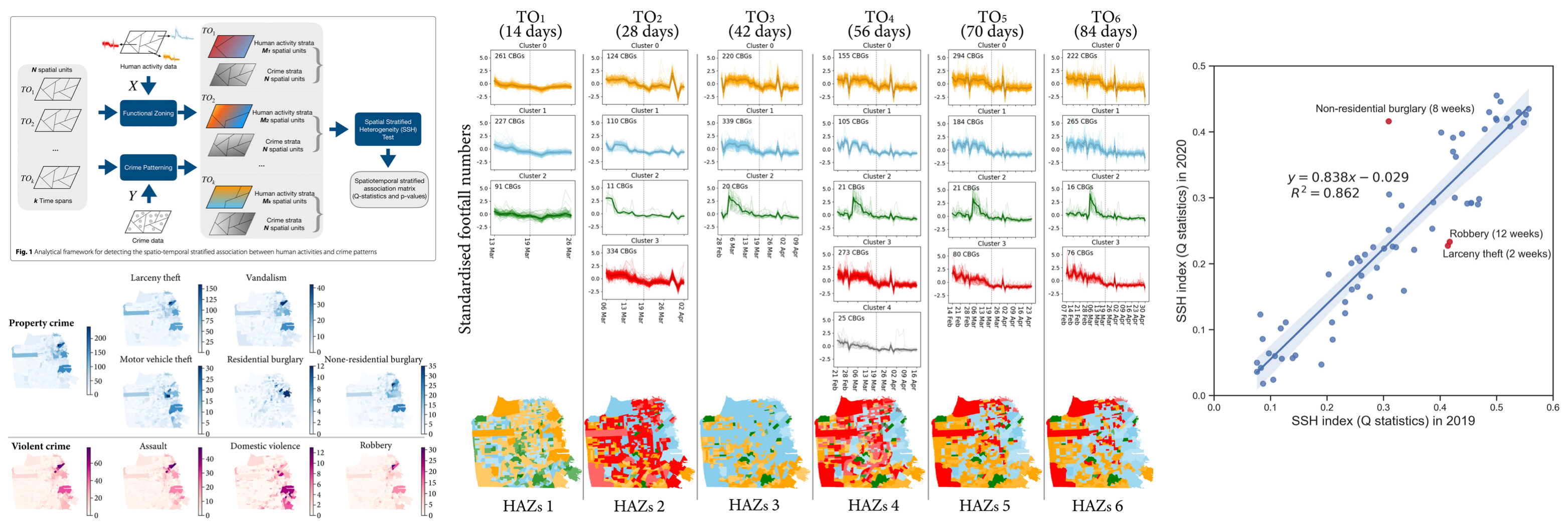
Spatio-temporal stratified associations between urban human activities and crime patterns: a case study in San Francisco around the COVID-19 stay-at-home mandate
Abstract: Crime changes have been reported as a result of human routine activity shifting due to containment policies, such as stay-at-home (SAH) mandates during the COVID-19 pandemic. However, the way in which the manifestation of crime in both space and time is affected by dynamic human activities has not been explored in depth in empirical studies. Here, we aim to quantitatively measure the spatio-temporal stratified associations between crime patterns and human activities in the context of an unstable period of the ever-changing socio-demographic backcloth. We propose an analytical framework to detect the stratified associations between dynamic human activities and crimes in urban areas. In a case study of San Francisco, United States, we first identify human activity zones (HAZs) based on the similarity of daily footfall signatures on census block groups (CBGs). Then, we examine the spatial associations between crime spatial distributions at the CBG-level and the HAZs using spatial stratified heterogeneity statistical measurements. Thirdly, we use different temporal observation scales around the effective date of the SAH mandate during the COVID-19 pandemic to investigate the dynamic nature of the associations. The results reveal that the spatial patterns of most crime types are statistically significantly associated with that of human activities zones. Property crime exhibits a higher stratified association than violent crime across all temporal scales. Further, the strongest association is obtained with the eight-week time span centred around the SAH order. These findings not only enhance our understanding of the relationships between urban crime and human activities, but also offer insights into that tailored crime intervention strategies need to consider human activity variables.
Citation: Chen, Tongxin, Kate Bowers, Di Zhu*, Xiaowei Gao, and Tao Cheng. "Spatio-temporal stratified associations between urban human activities and crime patterns: a case study in San Francisco around the COVID-19 stay-at-home mandate." Computational urban science 2, no. 1 (2022): 13.Chen, Tongxin, Kate Bowers, Di Zhu, Xiaowei Gao, and Tao Cheng. "Spatio-temporal stratified associations between urban human activities and crime patterns: a case study in San Francisco around the COVID-19 stay-at-home mandate." Computational urban science 2, no. 1 (2022): 13.
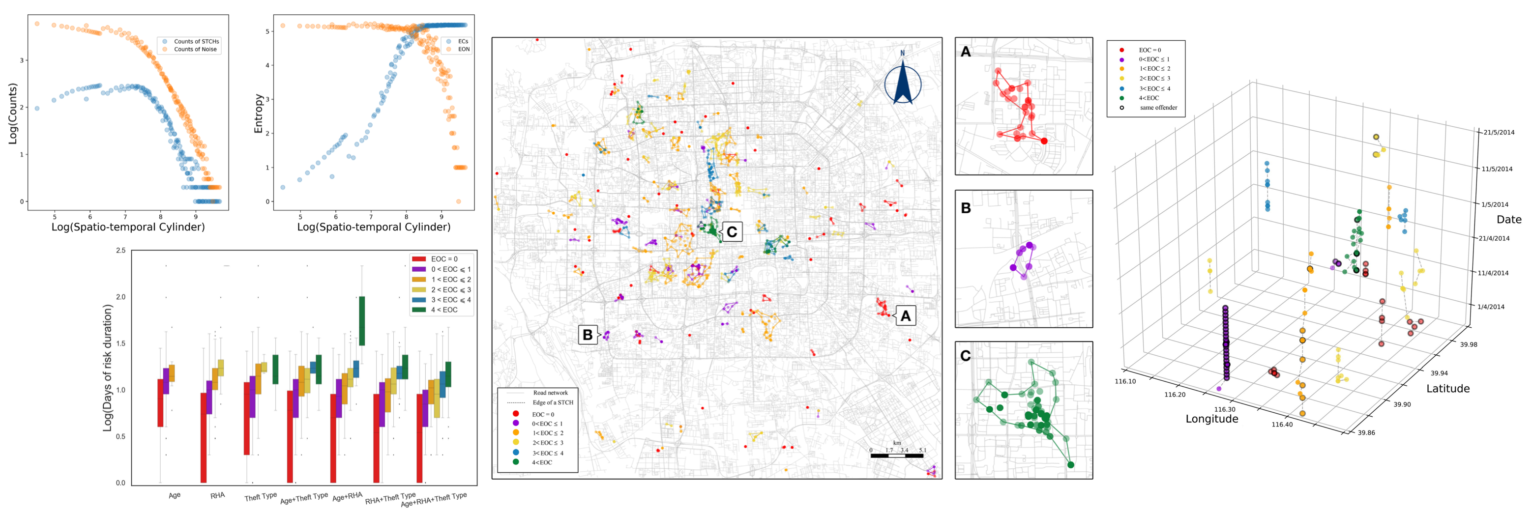
Exploring the homogeneity of theft offenders in spatio-temporal crime hotspots
Abstract: Offender homogeneity occurs when the same criminal group is composed of offenders with similar attributes (e.g., socio-economic-demographics). Exploring the homogeneity of offenders within spatio-temporal crime hotspots (STCHs) is useful for understanding not only the generational mechanisms of crime hotspots, but also has crime prevention implications. However, the homogeneity of offenders within STCHs has not been explored in criminological studies hitherto. Indeed, current techniques of STCH detection are limited to using statistical clustering methods in existing studies that lack the ability to identify the shape of STCHs or the distribution and variety of offences/offender activity with them. In this study, we utilise a spatio-temporal clustering algorithm called ST-DBSCAN to determine STCHs. We then propose novel entropy-based indices that measure the similarity of offenders (and offences) within STCHs. The method is demonstrated using theft crime records in the central area of Beijing, China. The results show that theft in the city is concentrated in a narrow space and time span (STCHs) and that within these associated offenders with similar social demographics, referred to as homogeneous offender groups are detectable.
Citation: Chen, Tongxin, Kate Bowers, Tao Cheng*, Yang Zhang, and Peng Chen. "Exploring the homogeneity of theft offenders in spatio-temporal crime hotspots." Crime Science 9, no. 1 (2020): 1-13.
Conference Papers
Chen, Tongxin*, Xiaowei Gao and Tao Cheng (2023).
Revealing the relationship between human mobility and urban deprivation
using geo-big data: a case study from London in the post-pandemic era
In: Geographical Information Science Research UK (GISRUK) 2023 Proceedings.
GISRUK: Glasgow, UK, April 2023.
Chen, Tongxin*, Tao Cheng and Di Zhu (2021).
The exploration of human activity zones using geo-tagged big data
during the COVID-19 first lockdown in London, UK.
In: Geographical Information Science Research UK (GISRUK) 2021 Proceedings.
GISRUK: Cardiff, UK, April 2021.
Chen, Tongxin* and Tao Cheng (2020).
Identifying Optimal Scales for Spatio-temporal Crime Clusters.
In: Geographical Information Science Research UK (GISRUK) 2020 Proceedings.
GISRUK: London, UK, April 2020.
Chen, Tongxin , Tao Cheng*, and Yang Zhang (2019).
Exploring the Homogeneity of Offenders in Crime Hotspots.
In: Geographical Information Science Research UK (GISRUK) 2019 Proceedings.
GISRUK: Newcastle, UK, April 2019.
Book Chapters
Cheng, Tao*, and Tongxin Chen. (2021).
Urban crime and security.
In: Shi, W., Goodchild, M.F., Batty, M., Kwan, MP., Zhang, A. (eds)
Urban Informatics . The Urban Book Series.
Springer, Singapore.
https://doi.org/10.1007/978-981-15-8983-6_14.